Loading 3D models...
The "Girdle Stane" near Letham, Angus
by dazx in architecture
1,473,194
Faces
737,895
Vertices
0
Textures
Free
Download
Description
Matcap will show the detail of the stone markings beautifully. It should be noted that a few more details are evident on this rendering compared to John Sheriff's 1995 illustration. 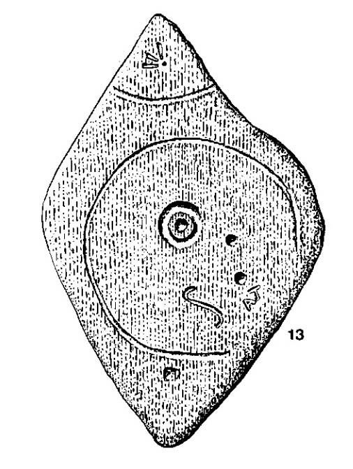 This stone is no longer in it's original postion, being moved 130 yards south from a road junction. The stone previously sat on the boundary between the parishes of Dunnichen and Rescobie. "Girdle" refers to the larger circle which resembles a cooking utensil of the same name. There is a cup and ring mark in the center with additional cup marks, an elongated S and more modern graffiti. Also visible are Ordnance survey marks. Plus one folk tale surrounds this stone :- “Tradition says a witch was carrying this boulder from ‘the Crafts’ of Carmylie in her apron, when the strings broke, and the stone fell where it now lies.” (Alex Warden 1882)
Technical Details
Related Models
Loom Weight
275,664 faces
Free
Pawn from Poly by Google
368 faces
Free
Magic Knife 1
3,640 faces
Free
Persian Graffiti, Dwarfie Stane, Hoy, Orkney
1,557,119 faces
Free
Hafted Tool XCB-003-443
43,702 faces
Free
Over The Garden Wall (Flat Colours)
8,016 faces
Free
field wars map
309,015 faces
Free
BLPL Courses 1-6
941,055 faces
Free